It’s hard to think of back-to-school season as anything other than an exciting new beginning. A new school year means new opportunities to learn, grow, and gain some independence; it’s also a new chance to make safe and healthy choices on and off the roads. The choices you make to achieve optimal health and safety can be simple—small changes to your everyday routine can create the greatest impact!
Guarantee a safe start to the school year by adopting a safety strategy that ensures you are rested, informed, and protected on and off the road. We’ve created some strategy tips for you that will contribute to a safe and healthy school year.
Ride the school bus as often as possible.
Did you know that students are 70 times more likely to get to school safely when taking the school bus than when traveling by car? The school bus is the safest method for getting to and from school and, when possible, it should be your preferred method of transportation. Before stepping foot on your journey to the bus stop, refresh your knowledge of safe school bus practices. Sit facing forward in your seat when the vehicle is in motion, buckle up if the bus is equipped with seat belts, and be aware of traffic on the roads when it’s time to hop off.
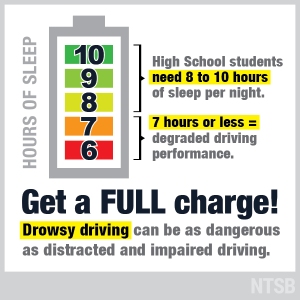
Get 8 to 10 hours of sleep every night.
Although extracurriculars are important, don’t forget to factor sleep into your schedule after the school day is over. Research shows that teens should get between 8 and 10 hours of sleep each night to guarantee they feel rested and refreshed for school in the morning. Make sleep a top priority on your schedule! Be sure to set bedtimes and stick to them. Checking your cellphone, watching television, and searching the Web on your laptop disturbs your sleep patterns and contributes to insufficient or interrupted sleep. If good grades and great school days are something you hope to achieve this school year, uninterrupted, quality sleep is key.
Avoid all distraction on your morning and afternoon commute.
If you drive to and from school, remember that driving safely requires all your attention. Between 2014 and 2015, fatalities in distracted-driving–affected crashes increased by over 8%. Send your text messages, make phone calls, set your music playlist, and mute your cellphone before you put the key in the ignition. It’s also important to keep your morning routine activities in the house and off the road. Eat breakfast at the table, not in the driver’s seat, and put your makeup on in the bathroom mirror, not the rearview mirror. To reduce crashes, injuries, and deaths, you must disconnect from all distractions and focus all your attention on the road.
Limit the number of passengers in the car on your way to and from school.
Just a few simple changes to your daily routine can create a safer environment for you and your peers. Not only will these small changes help you achieve and succeed this coming school year, but you’ll also be creating safer roads for your family, friends, and community.
Do you live within the school walk zone for your child’s school? If you do, that generally means that there is no school bus that serves your neighborhood, and you need to find an alternative form of transportation to get your child to and from school. If walking or bicycling is part of your child’s school transportation plan, be sure to prepare and plan ahead so your child will arrive safe and ready to learn.
Walking to School
Will your child walk to and from school? Children should walk with an adult or an older sibling until they are 10 years old. Map out the best and safest route for your child before school is back in session, and practice it a few times. This will get your child familiar with the route and with any crosswalks or intersections that may need negotiating. If possible, select a route with sidewalks, and try to avoid busy roads with high levels of traffic. Demonstrate safe walking behaviors by finding marked crosswalks or other designated crossing areas, stopping at any curbs and looking LEFT-RIGHT-LEFT before crossing the street. Check out the Safe Routes to School resource Teaching Children to Walk Safely as they Grow and Develop to guide children of all ages as they develop safe walking behaviors.
Bicycling to School
Your child is going to school to develop his or her brain; be sure to protect that brain with a helmet! Helmets are the most important piece of safety equipment for bicycle riders. Just as with walking, it’s also important to help your child select the safest bicycle route before starting the school year. This guide of bicycle skills a child should have before riding to school from Safe Routes to School can help you prepare your child for bicycling safely to and from school.
Safety Education is Continuous!
Whether your child is entering kindergarten or senior year, pedestrian and bicycle safety is a subject that can always be reviewed, practiced, and reinforced to ensure safe road behaviors continue throughout your child’s life.
This is the fourth blog in a new series of posts about the NTSB’s general aviation investigative process. This series, written by NTSB staff, explores how medical, mechanical, and general safety issues are examined in our investigations.
John O’Callaghan at a runway friction test in Conroe, TX.
As a National Resource Specialist for Aircraft Performance, which is government-speak for a technical expert in the aerodynamics and flight mechanics of aircraft, I work to determine and analyze the motion of aircraft and the physical forces that produce that motion. In particular, following an accident or incident, I attempt to define an aircraft’s position and orientation during the relevant portion of the flight, and determine its response to control inputs, external disturbances, ground forces, and other factors that could affect its trajectory.
I recently reviewed a 2009 cockpit video taken while I was testing a video recording device in a Bellanca Citabria. The footage called to mind recent NTSB cases that highlight the fallacies inherent in one of aviation’s oldest mantras—“see and avoid.”
The video from the camera mounted over my left shoulder reveals a hazy blue sky above and the Potomac River winding lazily below the Citabria’s plexiglass windows. It shows my head dutifully swiveling as I scan the practice area for traffic in preparation for a series of aerobatic maneuvers intended to test a prototype “portable flight data recorder” developed by a friend of mine. I’m flying in the Washington, DC, Special Flight Rules Area so I’m in contact with Potomac Approach, which helpfully keeps a radar’s eye on me and nearby traffic and conveys what I fail to see.
Images captured on the cockpit video during the testing of a video recording device in a Bellanca Citabria.
“Citabria 758, traffic about a mile southwest of your position. A Cherokee is in the practice area, altitude indicates . . . I’m not showing an altitude right now.”
On the video, my head moves around a little more as I respond, “758 looking, thank you.”
The controller then alerts the Cherokee. “Cherokee [call sign], traffic seems to be about 1-mile orbiting, altitude indicates 3,600, a Citabria.”
I’m still looking with no success when Potomac advises that the Cherokee is at 2,200 ft. The controller lets me and the Cherokee pilot know that we are getting close to each other.
“Cherokee [callsign], traffic just southeast of you, about less than 1 mile, Citabria in the practice area, altitude indicates 3,700.”
“Roger, we’ll keep our eyes open for that Citabria in the practice area.”
“Citabria 758, that traffic is just northwest of you, less than a mile now, and his altitude still indicates 2,300, appears to be eastbound.”
“758 still looking, thank you.”
The video now shows me craning my neck left and right, leaning forward, scanning the entire symmetrical view offered by an airplane with its seats on the centerline. The airplane banks left and right in gentle turns as I maneuver, trying in vain to spot the Cherokee. A little over 3 minutes after Potomac’s initial advisory, I give up.
“Potomac, Citabria 758 still looking for that traffic . . . is he still a factor?”
“758, now he’s about 5 miles north of you, no factor.”
I don’t know if the Cherokee pilot ever saw me, but if he did, he didn’t announce it. I imagine that most general aviation pilots don’t need to accumulate too many hours before they have an experience much like mine, or its more unnerving inverse: suddenly seeing an airplane that you had no clue about whiz by close enough to read the N-number. Both situations point to the inherent limitations of the “see-and-avoid” concept: the foundation of collision avoidance in visual meteorological conditions (VMC) under visual flight rules (VFR).
My flight was a personal one, unrelated to my duties as an aircraft performance engineer at the NTSB. However, my fruitless search for the Cherokee was consistent with conclusions the NTSB has drawn from investigating a number of midair collisions, and which call to mind what can happen when traffic remains unnoticed.
As detailed in the NTSB reports concerning two midair collisions that occurred in 2015, described further below, the see-and-avoid concept relies on a pilot to look through the cockpit windows, identify other aircraft, decide if any aircraft are collision threats, and, if necessary, take the appropriate action to avert a collision. There are inherent limitations of this concept, including limitations of the human visual and information processing systems, pilot tasks that compete with the requirement to scan for traffic, the limited field of view from the cockpit, and environmental factors that could diminish the visibility of other aircraft.
In a collision between an F-16 and a Cessna 150 near Moncks Corner, South Carolina, in July 2015, the F-16 pilot was unable to spot the C150, even though the Charleston Approach controller had alerted him to the presence of the airplane. The F-16, call sign “Death41,” was flying under instrument flight rules and communicating with air traffic control (ATC); the C150 was flying under VFR and not communicating with ATC.
“Death41, traffic 12 o’clock 2 miles opposite direction 1200 indicated type unknown.”
“Death41 looking.”
“41 turn left heading 180 if you don’t have that traffic in sight.”
“Confirm 2 miles?”
“Death41, if you don’t have that traffic in sight turn left heading 180 immediately.”
[unintelligible reply]
Even before the controller finished her last instruction, the F-16 had begun a standard-rate turn to the left. The F-16 was heavy and, at 240 knots, moving relatively slowly—for a fighter jet. Contrary to what one might think, it could not turn much faster in those conditions. Twenty-three seconds after the controller’s last instruction, the F-16 and the C150 collided at about 1,470 ft above the Cooper River. The crippled F-16 flew for another 2.5 minutes before the pilot ejected safely, and the jet subsequently crashed. The C150 crashed almost directly beneath the collision site, and both the pilot and his passenger died.
We determined the probable cause of this accident was the approach controller’s failure to provide an appropriate resolution to the conflict between the F-16 and the Cessna. Contributing to the accident were the inherent limitations of the see-and-avoid concept, resulting in both pilots’ inability to take evasive action in time to avert the collision.
Midair collisions can happen even when both aircraft are in communication with ATC. A month after the Moncks Corner midair collision, a North American Rockwell Sabreliner collided with a Cessna 172 in the busy traffic pattern at Brown Field in San Diego. Both aircraft were under Brown Tower’s control and on a right downwind for runway 26R, with the Sabreliner outside of and overtaking the C172. The tower controller intended to instruct the C172 to perform a right, 360-degree turn to position him behind the Sabreliner; however, he mistakenly instructed a different C172 to perform the maneuver, and immediately after instructed the Sabreliner to turn right base.
The Sabreliner and C172 subsequently collided, and all five people on the two aircraft died. The cockpit voice recorder on the Sabreliner indicated that both Sabreliner pilots were aware of and concerned about the busy traffic pattern, pointing out other aircraft to each other. One of the nonflying crew in the back of the plane is even heard asking, “see him right there?” presumably referring to traffic. Yet the collision still occurred.
We determined the probable cause of the accident was the local controller’s failure to properly identify the aircraft in the pattern and to ensure control instructions provided to the intended Cessna on downwind were being performed before turning [the Sabreliner] into its path for landing. Contributing to the accident were the inherent limitations of the see-and-avoid concept, resulting in the inability of the pilots involved to take evasive action in time to avert the collision.
My role in the investigations of the Moncks Corner and San Diego collisions was to reconstruct the motion of the airplanes based on radar data and other information, and to evaluate the resulting visibility of each aircraft from the cockpit of the other. In addition, it was my job to evaluate how new collision avoidance technology—such as cockpit displays that provide a radar‑like view of surrounding traffic based on automatic dependent surveillance-broadcast (ADS-B) information—could have averted each accident.
One objective of these visibility studies was to determine whether either of the airplanes involved in the collision were obstructed from the other pilot’s field of view by cockpit structures, or whether the pilots had an unobstructed view of each other but simply failed to see one another (because seeing other traffic from the cockpit is hard!). To find out, we measured the geometries of the window and other structures of exemplar airplanes with laser-scanning equipment, and the resulting measurements were used to determine where the windows were in each pilot’s field of view and whether the other airplane appeared within the windows or not. The results were most intuitively presented by creating computer animations of the collision from the point of view of each pilot using flight simulation software (Microsoft Flight Simulator X) to create the outside scenery and airplane models.
Readers can watch the animations we created for the Moncks Corner and San Diego collisions on our YouTube channel and judge the visibility results for themselves. The performance studies for these accidents provide technical details about the reconstructions, and they note that periods when airplanes are obscured from a pilot’s nominal field of view “underscore the importance of moving one’s head (and occasionally lifting and dipping the wings) so as to see around structural obstacles when searching for traffic.”
Readers can also watch animations of cockpit display of traffic information (CDTI) displays for each of the airplanes involved in these midair collisions. The animations depict the information that these radar-like displays, fed by ADS-B, could have presented to the pilots involved. Had the airplanes been equipped with CDTI, the pilots could have been made aware of the presence and relative locations of the conflicting traffic minutes before the collisions.
In general, the timely and information-rich traffic picture offered by a CDTI can greatly improve a pilot’s ability to detect traffic threats and avoid a collision without aggressive maneuvering. We issued a safety alert, titled, “Prevent Midair Collisions: Don’t Depend on Vision Alone,” to encourage pilots to learn about the benefits of flying an aircraft equipped with technologies that aid in collision avoidance.
Much of flying is an exercise in mitigating or engineering out risk. Pilots are trained, examined, and reviewed; aircraft are certified and maintained; checklists are used; flights are planned; weather is studied. Great effort is made to leave little to chance. However, when it comes to collision avoidance in VMC, we wink at risk management (“see-and-avoid!” “Keep your head on a swivel!”), when the reality is that we rely in great measure on luck. It’s a big sky, and it would be hard to hit somebody if you tried. The odds are against a collision, but on occasion, disaster strikes.
Technologies such as CDTI provide rational risk reduction for the VMC collision avoidance problem. Guardian angels will never lack for work, but tools such as CDTI can help us to make their jobs a little easier.
This is the third blog in a new series of posts about the NTSB’s general aviation investigative process. This series, written by NTSB staff, explores how medical, mechanical, and general safety issues are examined in our investigations.
Dr. Tuccio (seated) assists with the disassembly of a cockpit voice recorder.
I joined the NTSB in 2010 as a recorder investigator in the Vehicle Recorders Division. I work to recover “1s and 0s” from electronics, including cockpit voice and flight data recorders (aka “black boxes”) and video sources. As a recorder investigator, I work early in the investigative lifecycle to create factual reports of electronic data: if it might record something and has a green board or a little chip, we’re interested.
My formal training and experience is in aeronautical engineering, aviation, computer/database/iOs programming, and conversation analysis. I’m also a flight instructor, former regional airline captain, and aircraft owner. Through my work on more than 400 NTSB investigations and my 30 years as a flight instructor, I’ve had some incredible moments, but my most memorable is soloing my son in our tailwheel Maule on his 16th birthday. We enjoyed the usual fun so many pilots experience on soft fields, and it was a success. Now, about 10 years later, my son is a certified flight instructor-instrument (CFII) who has taught his own students.
Soft fields are fun, but they also carry risks that pilots have to manage. The FAA Airman Certification Standards (ACS) for private and commercial pilots include soft-field takeoffs and the separate (but arguably related) short-field takeoffs.
What do soft and short fields have to do with readouts of recorded data? Normally, nothing. When something goes wrong, however, the data can sometimes help piece together the story.
I recovered data from electronic devices in two soft-field investigations. Unfortunately, there were no survivors in either accident, but these fatal crashes highlight some of the risks noted in the ACS.
The first case involved a 1956 Cessna 172 in Veneta, Oregon, with four people on board. The airplane was just below gross weight and within center-of-gravity limits. According to other investigative information, the grass of the 3,200-foot runway was mowed to about 3 inches in height and was damp from a prior rain shower.
I was given an iPhone recovered from the passenger in the right front seat. It yielded some photos of the pilot and passengers before boarding and a video of the first 23 seconds of the accident flight. Below is a picture taken before boarding, showing the accident airplane with the runway environment behind. The tall grass immediately apparent in the photo obscures the runway, which is further in the background. This photo was useful to corroborate the weather conditions at the time of the accident.
Picture taken before boarding showing the runway environment.
The 23-second video also helped. It began when the aircraft was on its takeoff roll. We worked with the raw video as recorded, rather than subject it to labor-intensive postprocessing, which is sometimes necessary to stabilize the constantly shifting camera angle of an iPhone video. One significant feature of the video was that from the 15-second mark until the end of the recording, we could hear a sound similar to the stall warning. Some partial views of the instruments supported other evidence indicating that the engine was operating properly.
When combined with other investigative evidence, the NTSB determined the probable cause of this accident was “The pilot’s failure to maintain adequate airspeed and altitude to clear trees during takeoff initial climb.” (You can access the detailed factual reports here: https://go.usa.gov/xRGGe.) I often use this case while teaching students about soft- and short‑field takeoffs to emphasize the ACS risks of collision hazards, including aircraft, terrain, obstacles, and wires; low altitude maneuvering, stall, and spin; and runway surface conditions.
The second soft-field/short-field case that rested (in part) on my work with recorded data was the crash of a 1977 Cessna T210M in Challis, Idaho, also with four people on board, loaded to 3,551 pounds (maximum gross weight for this plane was 3,800 pounds) and within center-of-gravity limits.
According to other investigative information, the 5,500-feet mean sea level airport had a 2,500‑foot turf/dirt runway, with an estimated density altitude during the accident of 6,046 feet. Because of terrain features, pilots generally landed on runway 22 and departed on runway 4. The accident flight was departing on runway 4.
Two significant electronic devices were recovered from this accident: a JPI EDM-700 engine monitor and a Garmin GPSMAP 496 portable GPS device. Both have recording capabilities, but each sustained impact and postimpact fire damage requiring chip-level data recovery. The figures below show the JPI EDM-700 and Garmin 496 chips that were recovered.
Recovered JPI EDM-700 and Garmin 496 chips
Using tools in our lab, we removed the chips and cleaned them up. We then “imaged” the chips (that is, created a file of all the 1s and 0s on the chip) using a commercially available chip programming device. Our frequent experience with the JPI EDM-700 and Garmin 496 contributed to our efficient data extraction from the binary image to produce useful engineering data.
In this case, the JPI EDM-700 recorded the takeoff and supported other investigative information showing that the engine was functioning properly. As you can imagine, when working with recovered avionics, data can be confusing; in this case, the end of the recording had unchanging data. By comparing the accident takeoff data with a prior takeoff, combined with our prior knowledge of the EDM-700 recording logic, we were able to attribute the unchanging data to invalid data after the aircraft had crashed.
The Garmin 496 recorded the accident flight and 49 prior flights. Although the accident flight was undoubtedly helpful to the investigation, we also decided to compare the accident takeoff to nine prior takeoffs on the same runway, considering groundspeed and lateral path. The accident flight differed from all prior flights in that prior flights proceeded to the right of the accident flight’s trajectory near the departure end of runway 4.
Investigators worked with Cessna to calculate the takeoff performance. With no wind, to clear a 50-foot obstacle, the airplane would need 2,231 feet of runway. With a 5-knot tailwind, the airplane would need 2,677 feet. The actual distance from the start of the takeoff roll to the point at which the aircraft struck the first 50-foot tree was 2,625 feet.
Our report noted, “In the takeoff configuration, with the nose-high pitch, it is possible that the pilot’s windscreen view of the terrain would be limited.” We determined the probable cause was “The pilot’s attempt to depart in conditions that resulted in the airplane having insufficient performance capability, which resulted in a collision with a tree.” (You can access the detailed factual reports here: https://go.usa.gov/xRGGd.)
I often use this accident to teach my students the ACS short-field knowledge areas of the “effects of atmospheric conditions, including wind, on takeoff and climb performance,” as well as risk management regarding the “selection of runway based on pilot capability, aircraft performance and limitations, available distance, and wind.”
As Mike Hart wrote in AVweb, “If the calculated length of the field is less than the number calculated from the POH, don’t even think about turning your prop. An obvious accident is avoided.” He goes on to add, if the calculated distance is at all close, check your math and your assumptions. Pilot technique and aircraft condition are just two factors that can make a world of difference.
The electronic devices you use when you fly can increase your situational awareness and enjoyment. Some devices empower you to check historical engine trends and identify mechanical issues early. And, in the relatively rare cases when things go wrong, we can use this electronic information—all those 1s and 0s—to dig deeply into what went wrong and how, and help avoid a similar outcome in the future.
The Tremont Street Subway in Boston began service in 1897 as the first subway tunnel in North America. That subway tunnel was the beginning of the now complex rail transit system that is commonly known as the Massachusetts Bay Transportation Authority (MBTA), or “the T.” With an average of 1.3 million passengers riding its heavy rail, light rail, trolleys, buses, and ferryboats each weekday, this is one of the busiest transit systems in the country.
Member Hart with NTSB and MBTA staff at the MBTA rail operations center
I recently had the opportunity to tour the MBTA system and learn how such a complex legacy system is managed. I also heard about the collaboration that has developed between the MBTA and its safety oversight body—the Massachusetts Department of Public Utilities (MDPU). I often used the T years ago when I was in law school, so it was very informative to see how the system has grown and changed in the intervening years.
Improve Rail Transit Safety Oversight is on the NTSB’s Most Wanted List of transportation safety improvements to promote our recommendations addressing oversight of rail mass transit operations. It is critically important that rail transit systems be adequately monitored to maintain and enhance safety and to help ensure that small problems can be caught before they become big ones; our accident investigations have shown that an important part of that monitoring is effective safety oversight. This visit to the MBTA allowed us to observe some of those safety programs and their oversight.
Massachusetts is one of four states (the others being California, Colorado, and New York) that has the authority to compel a rail transit agency to comply with system safety program plans, Federal Transit Administration requirements, and state regulations or requirements. This authority has fostered a collaborative relationship between the MBTA and the MDPU for rail transit safety oversight. These two agencies are in regular contact about rail transit decisions; this open relationship enables faster resolution when issues arise and comprehensive planning to help prevent disasters from occurring.
Member Hart and Steve Hicks, MBTA Chief Mechanical Officer – Rail
It was very interesting to see the behind-the-scenes operations that keep everything running smoothly. We received comprehensive briefings from both the MDPU and the MBTA to better understand the system’s history, past and current safety challenges that the agencies face, and plans to improve safety systems and extend the service to serve more of the traveling public in the Boston area.
We also toured the MBTA Emergency Operations Control Center and learned how transportation and law enforcement officials work closely during major planned events, such as the Boston Marathon, the St. Patrick’s Day Parade, and the fireworks displays on July 4, and during unplanned emergencies, like weather events or disasters, to safely move as many people as possible under unusual circumstances.
Our MBTA guides took us underground to the new Emergency Training Center, built in former streetcar tunnels, to see where all MBTA operators, first responders, and law enforcement personnel receive emergency simulation training on heavy rail, light rail, and bus equipment and facilities.
Vehicle and equipment maintenance and upkeep are also part of good safety oversight and are needed to spot any actual or potential problems that may arise, diagnose them, and determine and implement a solution to keep everything running smoothly. To get some idea of that part of the operation, we toured the Orient Heights Car House and learned about the preventative maintenance program that helps ensure all cars are operating efficiently and safely.
On the second day of our tour, we rode the Green Line to get an in-depth look at this oldest subway line in the country. MBTA and MDPU personnel shared their progress toward implementing Positive Train Control—another item on our Most Wanted List—on this line, whose age, signal system, and street‑running sections present operational complexities and risks that the MBTA’s safety programs and oversight continuously seek to address.
The MBTA and the MDPU share the goal of providing and maintaining a reliable, safe transit structure to move the people of Boston safely and efficiently. We enjoyed and appreciated the opportunity to visit and learn so much about this legacy system. In the coming years, we plan to reach out to other mass transit operators and their regulators to learn, first hand, what they are doing to build safer systems and prevent future accidents, injuries, and fatalities.

 Although extracurriculars are important, don’t forget to factor sleep into your schedule after the school day is over. Research shows that teens should get between 8 and 10 hours of sleep each night to guarantee they feel rested and refreshed for school in the morning. Make sleep a top priority on your schedule! Be sure to set bedtimes and stick to them. Checking your cellphone, watching television, and searching the Web on your laptop disturbs your sleep patterns and contributes to insufficient or interrupted sleep. If good grades and great school days are something you hope to achieve this school year, uninterrupted, quality sleep is key.
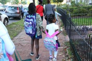 Do you live within the school walk zone for your child’s school? If you do, that generally means that there is no school bus that serves your neighborhood, and you need to find an alternative form of transportation to get your child to and from school. If walking or bicycling is part of your child’s school transportation plan, be sure to prepare and plan ahead so your child will arrive safe and ready to learn.
 Your child is going to school to develop his or her brain; be sure to protect that brain with a helmet! Helmets are the most important piece of safety equipment for bicycle riders. Just as with walking, it’s also important to help your child select the safest bicycle route before starting the school year. This guide of


